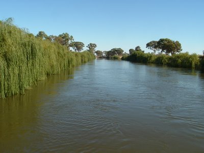
 This is the Murray river still about 600 miles from the ocean.
I'm the first to admit it doesn't look like a river that's in trouble, but
sadly there are some serious problems, hopefully it's not too late to
fix them.
 This is not another river, it's the main irrigation chanel near Lake Mulwalla,
this one is 80 feet wide and about 20 feet deep, so you can imagine it holds a
lot of water even when it's not flowing there is a huge undertow when the
chanels are running, swimming is forbidden, but, Aussies being Aussies that is
ignored quite often, sometimes with disasterous results
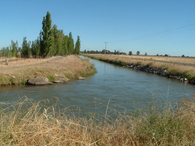
 The chanels drop down in size as they travel further away from the source, this
is a secondary chanel about 30 feet wide and 10 feet deep, again the flow can
be quite strong when water is being delivered.
 This is a small chanel about 10 feet wide and 4 feet deep, typical of the ones
that farmers draw their water for irrigation from, often this is done by flood
irrigation through their own smaller chanels, to work effectivly the land is first
"Laser Levelled" with just the slightest fall to one side for the flooding to work.
In all there are thousands of miles of these chanels of various sizes, and
millions of acres of land irrigated by them.
There is of course a charge for water supplied, measured by an ingenious water
wheel device at each draw off point, there is also a strictly controlled
"water right" for each property.
I have made mention before that
(I wonder does that mean we are incontinent?) with a vast amount of water
flowing in relatively short rivers to the sea, providing very limited opportunities
for this water to be used, the exception to this rule is the mighty
which for much of it’s course marks the State boundary between
New South Wales
The headwaters of the Murray are in the mountains that make up the great
dividing range which run north/south for 2000 miles, melting snow and
countless little tributary streams feed this river, which also flows for a little
over 2000 miles mainly in an east/west direction.
In early times there were floods almost every year which would cover low lying
land for many miles, now and again there would be a major flood which would
inundate towns and vast areas of farming land.
The river course which was lined with “River Red Gums” was often 20/30
miles wide in these big floods, this had been the pattern of things for millions
of years and everything seemed to work out right in the end.
Then a little over 200 years ago came white settlement; the river flats which
had been building up with very fertile silt over the millenniums was the best
farming land, the forests of River Red Gum were found to produce excellent
mill-able timber, which was termite resistant as well, the vast areas that were
flooded in major floods were found to be excellent soils only lacking one thing,
water.
I’m sure you can see a pattern emerging here, over a period of about 50 years
there were 4 major dams built to contain the rivers water flow there were
huge irrigation schemes put in place to enrich the flat plain soils, as well there
were vast tracts of timber cleared so that the farming land could be extended.
An interesting aside to these dams was that there were locks installed to allow
boats to travel the length of the river as before, by boats entering the locks
and the water level being raised or lowered depending on which way the boat
was traveling they could still proceed up or down river.
This irrigation led to the establishment of our very large fruit and grape
growing areas, (Shepparton, where my sister lives is one of these areas)
once again everything was fine for quite a few years, but then it was
discovered that salinity, (naturally occuring salt from underground water)
was spreading.
There were two main reasons for this, over watering of dry land which was
soaking in and raising the underground water table, which carried salty water
in some places, the other problem came about because of the clearing of the
river red gum forests, these trees over the years had sucked up excess water
from underground reserves and kept the water table fairly constant.
So today we have a network of irrigation channels carrying water to huge
tracts of land which has become vastly more productive, a river system that
has been used so efficiently that the river mouth has silted up and hasn’t
been able to flush out to sea for so long that the lower reaches are becoming
very salty.
The news isn’t all bad, we have huge tracts of fertile ground which used to be
almost desert, and having recognized the problems some twenty years ago
there has been a lot of effort put into fixing the problems, things like replanting
trees, but with tiny plants not the 200/300 year old giants that were cut down,
and stricter control of water use, so this is a slow process and we are still only
hoping they’ve got it right this time.
To help this work we need Hoss' Big Ernie to help out with a major flood, there
hasn't been one for about twenty years, and while in the short term this is
costly, longer term benifits would be enormous.
Sorry this turned out to be such a long and complex post, but it’s a subject
I feel strongly about.

13 comments:
I think you are right about needing a flood. You use the rain we had here in the Northeast last May - rain 22 days of the month.
...Hoss could probably team up with Big Ernie and do a rain dance for you 'down-unders.'
I think if you had the U.S. Army Corp of Engineers, like we do, you could have been totally screwed way before this.
Hi Peter ~~ What a LONG post. Only skipped through it, but I will print it!
Jacqui and Walter are here for the night and going to see Keith tomorrow, Ann has to play golf, as she put it off last
week for you know who!!.
Will catch up later. Cheers, Merle
Peter,
What an interesting post! I really enjoy reading about your country!
My husband has always had a fascination with Australia,
and we've often wished we could visit. Probably never WILL tho-but your stories and history makes it more REAL for us!
Junie
I'll be wishing for rain for you guys. LMAO @ "I wonder does that mean we are incontinent?" That was too funny.
Lois Lane
Not at all, Peter. Very informative. Thanks.
We in Michigan are always worried that folks, like those out in the west, might want to tap our Great Lakes to relieve a water shortage. We like our lakes just the way they are.
Don't apologize. That was a very interesting and informative post.
I haven't known many Aussies but it seems that they are all far more ecologically aware and ecologically responsible than we are in the states.
Interesting and informative post. I've read that some places out in the western U.S. have been fighting over water rights for years. ec
All the talk about canals & water channels reminded so much of where we lived in CA. Our ranch had two canals on either end of it. These are very dangerous and people drown often because they ignore the warnings.
Water from Northern CA is pumped and channeled to Southern CA. It's quite an amazing thing.
Hi Peter ~ What do you mean I don't read the posts/ I had visitors who were watching
Dancing with the stars. So I printed it.
Surprise!!
I managed to post a link to Jacqui after
I saw your comment to June "do it from
blogger". Like her I had no palette showing. But it is on now.
umm, Peter, OK fer those of you up north where it rains a lot, t theorise about water. But fer those of us in South Aust, at the end of the sewer (the Murray - Darling river system) the situation has been critical fer quite some time. IF, NSW can let the snows of the Mountains through, IF the rice and cotton conglomerates in Qld and NSW will stop pinching millions of hecalitres, IF the grape and citrus growers in Vic and SA can learn to use less .. mebbe some of the River red gums might live, the saltpans will vanish, cities in South Aust might enjoy clean water for a change. (not to mention the millions spent on dredging the mouth of the river, so perhaps we could spend it on hospitals and schools)
I started reading this post yesterday but I was in a rush to get to work and now the pictures are showing up. Great post Peter!
It's neat to hear about things like this.
Take care, Meg
Post a Comment