When the idea for this post first came to me I very nearly tossed the idea away, too boring a project for my readers, who are used to my scintillating wit and humour, to be interested in.
Who’s blog is it anyway? was my next thought, and that dear reader sealed your fate, so here is a story about one of the worlds largest man made inland water storages.
It is not going to be possible to write this without a lot of facts and figures, but I’ll steer clear of the cut and paste direct from research material as much as possible.
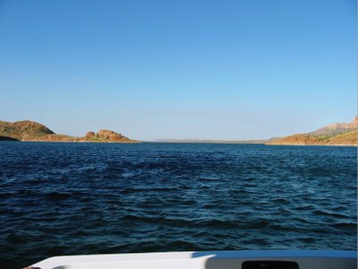
Lake Argyle.
The lake filled to capacity in 1973, and the spillway flowed until 1984. Since then wet season rainfall has been insufficient to bring the lake above its design capacity of about ten times the volume in Sydney Harbour. The normal area of the lake is 980 square kilometres, holding 5672 million cubic metres.
The flood surface area is 2072 square kilometres, holding six time the normal capacity, or 34655 million cubic metres of water that’s about 60 times the capacity of Sydney Harbour.
Now that is pasted direct but I think it is;
(a) important that we try to define the physical size, and;
(b) try to draw a picture of just how much water is impounded here.

Sydney Harbour fearuring two of the most recognised structures in the world, the Harbour Bridge and the Sydney Opera House.
We Australian’s have developed a habit of defining other bodies of water by comparing them to Sydney Harbour, which by the way is regarded by many as one of the worlds finest harbours.
Botany Bay, (Sydney Harbour) is 19 km long with an area of 55 km². The estuary's volume at high tide is 562 million cubic metres. The perimeter of the estuary is 317 kilometres.
That’s pretty dry stuff (if you will pardon the pun) I admit, but if you can think of it in terms of lake Argyle being about twice the size of Lake Erie in the Great Lakes system you will get the idea that it’s quite large.
Couple that with the fact that it is located in a very remote area and for 6 to 8 months of the year is very dry you start to get a picture of just how much rain falls here in the WET season.
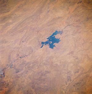
As seen from space the arid nature of this area is evident, the area shown would approximate the catchment area for the scheme.
The Ord River Irrigation Scheme was an ambitious and controversial undertaking. Originally, it was designed to bring intensive irrigated agriculture to Australia’s remote north, with cotton the predominant crop. Costs of insect pest control, marketing and production, however, proved to be higher than the profits. Things improved when problems with the growing of alternative crops, such as sugar cane, were overcome, but economic difficulties remained.
Located in the Kimberley region of Western Australia near the town of Kununurra the Ord Irrigation Area is among Australia’s most productive agricultural areas, the Ord River Irrigation Area located on the flat land to the south and west of the Kununurra township.
In the beginning.
Following much research by the government of Western Australia, in 1963 work was begun on the Kununurra Diversion Dam, funding was provided by the Commonwealth and Western Australian governments.
This was the first step in Stage 1 of the Ord River Irrigation Scheme. Water stored in the diversion dam was plentiful enough to irrigate 30 farms that were established close by. At the same time, the town of Kununurra, which had also been established in 1963, began to grow steadily as employment prospects and a small range of support businesses and industries began to develop.
Stage 1 of the Ord River Irrigation Scheme was completed with the construction of the main Ord River Dam 50 kilometres to the south of the Kununurra township. This dam (opened in 1972) formed a major water reservoir, Lake Argyle, which quickly became the largest freshwater storage reservoir in Australia. It stretched over 60 kilometres in length and over 40 kilometres in width. Lake Argyle stores about 10 times the volume of water contained in Sydney Harbour!
Remember in maximum flood this can expands to 60 times the volume of Sydney Harbour.
Lake Argyle's freshwater source.
The area surrounding Kununurra receives most of its rain within a three-month period (during summer). Known locally and across Australia as ‘the wet’, rainfall in Kununurra during these months is in the range of 500 to 800 millimetres. (Note: on average, Perth receives 865 millimetres in rainfall over a twelve-month period.)

Before construction of the Ord River Dam, summer rainfall discharged rapidly through the Ord River and into the Cambridge Gulf. This raised the level of the river markedly, whereas the lack of rainfall during ‘the dry’ usually saw the Ord River diminish to little more than a series of gradually shrinking pools over the winter months. However, the damming of the Ord River and the creation of Lake Argyle has meant that the summer rainfall is now contained in the reservoir, and released gradually to irrigated downstream farms throughout the year. This has changed the nature of the Ord River from an intermittent to a perennial one with fairly constant water levels throughout the year.

The main dam wall is 99 m high and 318 m long.
As well as this main wall there are other areas where some smaller walls needed to be built to contain the huge amount of water.
Because of the possibility of earth quake damage to a wall of this size it was designed as a dry rock wall.
It was not just any old rock used in the construction fortunately there was a source of suitable rock to build the wall nearby so vast quantities were blasted and transported to the wall site.
Hydroelectricity.
The dam at Lake Argyle supports a hydroelectric station, which can produce up to 30 megawatts. The station provides electricity to the townships of Kununurra and Wyndham, and to the nearby Argyle Diamond Mine.
The hydroelectric station provides a clean source of energy to the region. It does work equivalent to that of three diesel power stations. Three such stations would produce up to 200 000 tonnes of carbon dioxide emissions each year – a source of pollution that the Kimberley region (and in a global sense, all of planet Earth) can well do without.
In its history to date, there has always been enough water in Lake Argyle to keep the hydroelectric station operating. With a catchment area in excess of 46 000 square kilometres, the level of water behind the dam wall has never fallen below the critical level of 78 metres needed to keep the power station operating.
The Future?
As Australia’s population expands and our climate seems to enter a dry period there is an ever increasing call to pipe water from the North where the wet season produces vast quantities of fresh water that just washes out to sea in flood proportions each year.
For this water to reach Perth, the capital city and major population centre, some 3000 km of pipeline would have to be built, the cost of this would be enormous, but the cost of not building it may well be many times more in lost opportunity for expansion to the industries needed to sustain Perth.
A factor in this is that Perth sits alone on our west coast and is between 2000 and 3000 km from other manufacturing plants etc which are predominately on the east coast.
It’s an interesting dilemma that has yet to be tackled here and also on the east coast where again vast quantities of wet season rain just washes out to sea totally unused for fresh water or power generation.
Our rivers with the exception of the Murray - Darling system flow mainly straight out to sea and are not by world standards very long.


12 comments:
Hi Peter, Pity we don't have a couple more of these in this dry land of ours. Take care, Merle.
Peter, thanks for your hard work. Over here we just don't have an idea of what all is in Australia.
We have a small lake here, Lake Conroe, but it has been dry since the wave action from Huricane Rita last summer, a year ago damaged the dam. The dam has been repaired but the rains haven't come.
How does your dam compare with the Three Gorges Dam on the Yangtze River in China?
http://www.irn.org/programs/threeg/
A very informative and well researched post!
Thanks again.
..
Peter -- Those are what we call 'horse apples.' They aren't edible. I checked on your Custard Apples, they sound pretty good.
I have a fairly comprehensive post about them for July 2, 2006. Pictures of the trees are scattered across my blogs. The reference link about horse apples on the July 02 blog isn't the best, better is
http://davesgarden.com/pf/go/54097/
Other common names are Osage Orange and Hedge Apple. They are native to this area (maybe the Spaniards brought them in with horses?).
You can do a Technorati search, put apple in the little red search this blog box just below my Site Meter. It found thirteen blogs about these apples for me.
..
http://jimmiehov.blogspot.com/
..
Wow, that was like a term paper! I give you an A+.
Maybe it's the Steve Irwin affect, but I'm wondering whether there are any crocs in that big lake. Or any wildlife for that matter. (Fish?)
Nice history lesson there and lovely clear photo's very nice.
Hi Peter
The shade of blue is so rich.
I like it very much =)
WOW! Now that is a BIG lake. Especially when you compare it to Sydney Harbour, which I thought was HUGE! ~ Nice Post Peter!
Great post, Peter. I've never been to WA, but it looks amazing. It's a shame, that for such a big country, with such a small population, we have such a problem with water. Especially at the moment. Wish we had the wet season they have up north and over in WA, if only to fill our dams.
Have a great week.
Take care, Meow
Hello Peter, enjoyed your very interesting and informative post. The photo comparison to sydney Harbour was a little mind boggling. Seeing a comparison of that magnitude really drives the point home. Cheers Margaret
Wow - you should make a docmentary. Sure glad you put in those comparisons - i need all the help i can get - especially when you start using metrics. eek!
I cannot believe this only displaced 1 family - amazing. I did watch the China dam docemntary - it was incredible. Someday i think they will rule the world. Scary.
Good post!
WOW...that sure is a big lake and I hope they go ahead and build those pipe lines to supply water to other dry places.
Peter...you really did some research on this and it was very interesting because we have heard that parts of Australia is in a 10 year draught. Apparently here they have plenty of water. I read the post after this one and I never thought about the freshwater crocs and I'm glad you said that they didn't eat people, but preferred fish instead. What a relief.
Very, very interesting post!
Post a Comment